
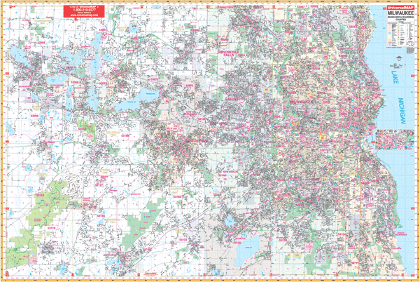
Milwaukee and Waukesha County WALL Map, Wisconsin, America.
$249.95
In stock
Scale 1:2,640. Size 77" W x 54" H. Laminated. Up-to-date cartography in complete street detail with new streets and changes graces this 2003, 3rd edition Wall Map of Milwaukee and Waukesha Counties, Wisconsin by Universal Map. Streets are indexed in a separate book. Includes all of the Greater Milwaukee area with the boundaries as follows: North: to the Washington/Ozaukee County lines; South: to the Walworth/Racine County lines; East: to Lake Michigan; West: to the Jefferson County line. Includes an inset map of Downtown Milwaukee. The special features and data are as follows: all streets and highways, government buildings, airports, golf courses and country clubs, railroads, ZIP codes and ZIP code boundaries, shopping centers, water features, recreational parks, cemeteries, educational facilities, hospitals, post offices, city limits and annexations, section/township/range lines, fire and police stations, and miscellaneous points of interest. Framing rails are included on top and bottom for easy wall mounting. Railed wall maps can be turned into pull down maps on spring rollers for an additional $40.
Scale 1:2,640. Size 77" W x 54" H. Laminated. Up-to-date cartography in complete street detail with new streets and changes graces this 2003, 3rd edition Wall Map of Milwaukee and Waukesha Counties, Wisconsin by Universal Map. Streets are indexed in a separate book. Includes all of the Greater Milwaukee area with the boundaries as follows: North: to the Washington/Ozaukee County lines; South: to the Walworth/Racine County lines; East: to Lake Michigan; West: to the Jefferson County line. Includes an inset map of Downtown Milwaukee. The special features and data are as follows: all streets and highways, government buildings, airports, golf courses and country clubs, railroads, ZIP codes and ZIP code boundaries, shopping centers, water features, recreational parks, cemeteries, educational facilities, hospitals, post offices, city limits and annexations, section/township/range lines, fire and police stations, and miscellaneous points of interest. Framing rails are included on top and bottom for easy wall mounting. Railed wall maps can be turned into pull down maps on spring rollers for an additional $40.
| Item Price | $249.95 + $24.80 p&h (add $40 for spring rollers) |
|---|
Write Your Own Review