
$249.95
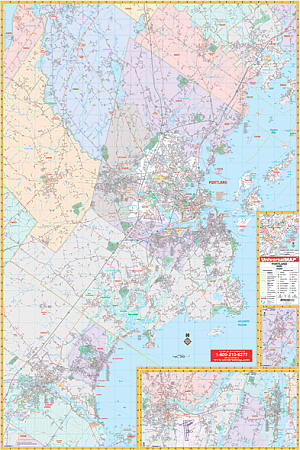
Scale 1:1,980. Size 51" W x 76" H. Laminated. Provides up-to-date cartography. Printed in color with a markable/washable-laminated surface. Streets indexed in a separate book. Includes hanging rails mounted top and bottom. The area of coverage ranges: North: to include all of Yarmouth, most of Windham to St. Joseph's college in Standish; South: to include Biddeford and Saco in York County; East: to the Atlantic Ocean; West: to Biddeford and Gorham. Insets: Downtown Portland, Freeport, and Brunswick. Details include airports, cemeteries, hospitals, railroads, post offices, all streets and highways, shopping centers, water features, recreational parks, mileage circles, city limits/annexations, government buildings, fire/police stations, educational facilities, golf/country clubs, ZIP codes/boundaries, and points of interest. Railed wall maps can be turned into pull down maps on spring rollers for an additional $40.
Write Your Own Review