
$229.95
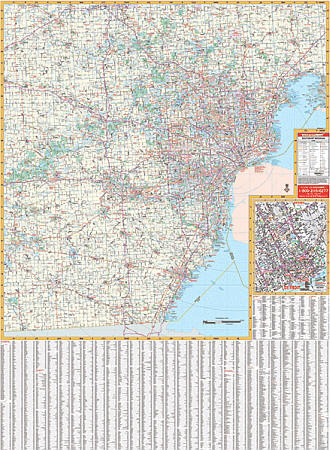
Scale 1:165,000. Size 46" W x 64" H. Laminated. The 3rd edition railed Southeast Michigan Wall Map by Universal Map shows Livingston, Macomb, Monroe, Oakland, Washtenaw, and Wayne. Features all national interstates, U.S./state highways, all principal county and municipal roads in detail, airports, government buildings, shopping centers, golf courses/country clubs, mileage circles, city limits/annexations, railroads, fire/police stations, hospitals, block numbers, educational facilities, ZIP codes/boundaries, recreational parks, water features, longitude/latitude lines, and more. Printed in color with a markable and washable laminated surface. Cities indexed on the face of the map. Framing rails are included on top and bottom for easy wall mounting. Railed wall maps can be turned into pull down maps on spring rollers for an additional $40.
Write Your Own Review