
$249.95
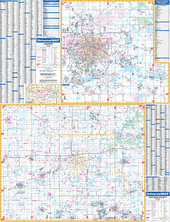
Scale 1:2,410. Size 50" W x 65" H. Laminated. Provided is up-to-date cartography with new streets and changes. Printed in color with a markable and washable laminated surface. Streets are indexed on the face of the map. The area of coverage is as follows: Section One which is the city of Jackson -scale of 1" = 2,410 feet ranges: North: to the State Prison Farm; Root Station Rd: South: to Jackson Community College; Crouch Rd. & Stoney Lake Rd; East: to Wolf Lake Rd; Waterloo Recreation Area; West: to Reynolds Municipal Airport; Hickory Hills Golf Course: Section Two is Jackson County provides. Other details and data found with this map include all streets and highways, post offices, hospitals, water features, recreational parks, mileage circles, city limits and annexations, cemeteries, shopping centers, block numbers, golf courses and country clubs, ZIP codes and ZIP code boundaries, airports and railroads, government buildings, fire and police stations, educational facilities, longitude and latitude lines, section/township/range lines, and other points of interest. Framing rails are included on top and bottom for easy wall mounting. Railed wall maps can be turned into pull down maps on spring rollers for an additional $40.
Write Your Own Review