
$229.95
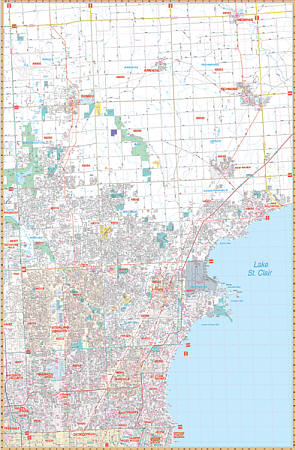
Scale 1:2,560. Size 52" W x 70" H. Laminated. The 2009, 5th. edition of the Macomb County, Michigan Wall Map by Universal Map includes the cities and towns of Armada, Center Line, East Pointe, Fraser, Memphis, Mt. Clemens, New Baltimore, New Haven, Richmond, Romero, Roseville, St. Clair Shores, Sterling Heights, Utica and Warren. Printed in color with a markable/washable-laminated surface. Streets indexed in a separate. Area of coverage: All of Macomb County and adjacent areas. Boundaries: North: to the St. Clair County Line; South: to the Wayne County Line; East: to the St. Clair County Line; West: to the Oakland County Line. An inset map includes SE Michigan, North to Flint, West to Lansing, South to Toledo, and East to Port Huron. Special features and data are as follows: all streets and highways, government buildings, shopping centers, airports, golf courses and country clubs, mileage circles, longitude and latitude lines, post offices, hospitals, cemeteries, railroads, block numbers, educational facilities, fire and police stations, ZIP codes and their boundaries, recreational parks, water features, city limits and annexations, section/township/ranges, and points of interest. Railed wall maps can be turned into pull down maps on spring rollers for an additional $40.
Write Your Own Review