
$249.95
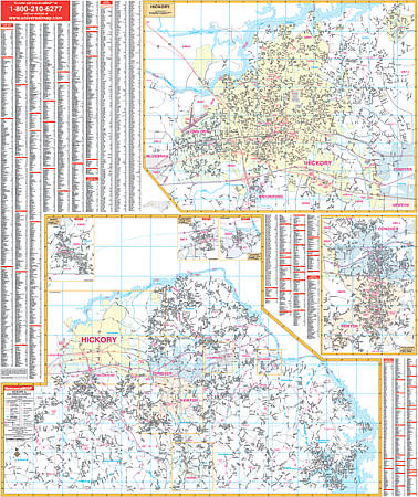
Scale 1:1,584. Size 54" W x 64" H. Laminated. Printed in color. Surface laminated so it can be marked on and washed off. Street Indexing is on the face of the map. Includes hanging rails top and bottom for mounting. Covers all of Hickory with the following boundaries: North: to the Caldwell County line; South: includes all of the town of Brookford; East: includes Lake Hickory Country Club and portions of Conover; West: to Longview and Hickory Regional Airport. Contains inset maps of Catawba (town), Claremont, Newton-Conover, and Maiden; and Catawba County with remaining residential streets. Shows airports, all streets and highways, government buildings, cemeteries, shopping centers, golf courses and country clubs, hospitals, water features, educational facilities, railroads, recreational parks, fire district lines, mileage circles, points of interest, ZIP codes and boundaries, city limits, and annexations. Railed wall maps can be turned into pull down maps on spring rollers for an additional $40.
Write Your Own Review