
$249.95
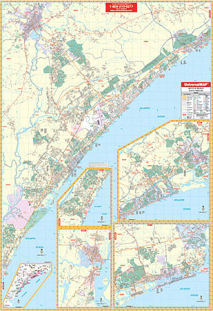
Scale 1:2,514. Size 54" W x 77" H. Laminated. The 5th Edition Myrtle Beach, South Carolina Wall Map by Universal Map features up-to-date cartography in complete street detail with new streets and changes. Printed in color, laminated, indexed for streets in a separate book. Coverage ranges: North: to Conway, SC and Calabash/Brunswick Plantation, NC; South: to Litchfield Beach, Pawley's Island, and Pawley's Plantation Golf and Country Club; East: to Atlantic Beach, SC and Shallotte, NC; West: to Conway, SC and Brookgreen Gardens. Also includes insets for Gerogetown, SC, a vicinity map, continuing coverage from the main map of the Pawley's Island area, North Myrtle Beach, and NC beaches to Holden Beach. Details airports, all streets/highways, government buildings, cemeteries, hospitals, railroads, post offices, longitude/latitude lines, shopping centers, water features, recreational parks, mileage circles, fire/police stations, educational facilities, golf courses/country clubs, and ZIP codes/boundaries. Framing rails are included on top and bottom for easy wall mounting. Railed wall maps can be turned into pull down maps on spring rollers for an additional $40.
Write Your Own Review