
$17.95
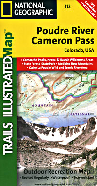
Scale 1:41,000. Size 22"x32". The Poudre River/Cameron Pass Trails Illustrated map is the most comprehensive recreational map for this beautiful area surrounding the northern portion of Rocky Mountain National Park in Colorado.
Coverage includes: Arapaho and Roosevelt national forests; Pingree Park; the Rawah; Commanche Peak; Neota wilderness areas; Cameron, Montgomery and Grassy passes; the Colorado State Forest; the cities of Indian Meadows, Spencer Heights and Glen Echo; Chambers Lake; Cache La Poudre and Laramie rivers; Comanche and Joe Wright reservoirs.
Write Your Own Review