
$249.95
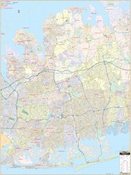
This Nassau County, New York Wall Map by Kappa Map measures 54” x 72” (4'6" W x 6' H) using up-to-date cartography showing new streets and changes, plotted in complete street detail. Printed in color with a markable/washable—laminated surface. Streets indexed in a separate book. Framing rails are included on top and bottom for easy wall mounting. Railed wall maps can be turned into pull down maps on spring rollers for an additional $30.
Area of coverage: North: to Long Island Sound; South: to the Atlantic Ocean; East: to Huntington; West: to the John F. Kennedy Airport.
Details include all streets and highways, government buildings, airports, water features, fire/police stations, hospitals, shopping centers, educational facilities, railroads, recreational parks, golf/country clubs, city limits/annexations, cemeteries, ZIP codes/boundaries, and points of interest.
Write Your Own Review