
$17.95
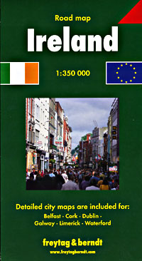
Scale 1:350,000. Size 36"x42". Fully indexed. Ireland Ordnance Survey and Freytag & Berndt edition. Shows all of Ireland and Northern Ireland, all types of roads, road numbers, distances between points in kilometers, tunnels, railways, train stations, cities, towns, and villages, nature reserves, tourist information booths, race courses, caravan sites, hostels, golf courses, lakes, canals, rivers, beaches, boating activities, lighthouses, lifeboat stations, scenic routes, view points and panoramic views, county boundaries, car ferries, monuments, and altitudes in meters. Excellent map.
Write Your Own Review