
$12.95
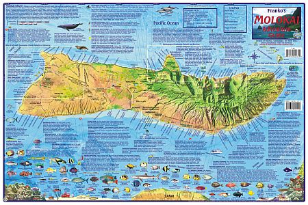
Various Scales. Size 14"x21". Laminated. This informative folded guide map of Molokai shows scuba diving, snorkling, boating, fishing, beaches, exploring, accomodations, historical and scenic sites along with extensive text regarding the sites. One side shows the complete island of Molokai, the reverse has insets of the West End and Maunaloa Town, Kalaupap Peninsula, Kaunakakai Town, and the East End and Halawa Valley. Map includes wonderful drawings of the reef fish and other sealife.
Franko's Maps produces recreation maps for the land and water of selected tourist destinations. The maps are all printed on plasticized paper so they are water resistant.
Write Your Own Review