
$17.95
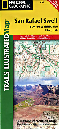
Scale 1:90,000. Size 25?"x38". Trails Illustrated edition. Printed on waterproof, tear-resistant, lightweight, paper-like plastic. This Trails Illustrated topographic map is the most comprehensive and complete recreational map for Utah's San Rafael Swell area. Coverage includes: San Rafael Reef; Green River; Huntington; Castle Dale; Muddy Creek and San Rafael River; Upper and Lower Black Box; the Chute; Cedar Mountain; the Wedge; Sids Mountain Wilderness. Study Areas: San Rafael Reef; Crack Canyon; Muddy Creek; Devils Canyon; Sids Mountain; Mexican Mountain; Goblin Valley State Park; Cleveland-Lloyd Dinosaur Quarry.
Write Your Own Review