
$16.95
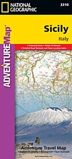
Scale 1:200,000. Size 26"x38". National Geographic edition. National Geographic's Sicily Adventure Map is designed to meet the unique needs of adventure travelers—detailed, durable, and accurate. Sicily includes the locations of thousands of cities and towns with an index for easily locating them, plus a clearly marked road network complete with distances and designations for expressways, motorways, scenic routes, and more.
What sets National Geographic Adventure Maps apart from traditional road maps are the hundreds of points of interest that highlight the diverse and unique destinations within Sicily. National Parks, archeological sites, prehistoric monuments, museums, palaces, castles, churches, monasteries and more are noted making this map indispensable for travelers seeking to experience all the history, art, and culture this amazing region has to offer. Users will find a variety of helpful travel aids on our map as well, including the location of airports, airfields, railroads, lighthouses, ferry routes, harbors, and petrol stations.
Sicily’s western half is shown on the front side of the map including the cities of Trapani, Palermo, Caltanissetta, Licata, Agrigento, Sciacca, Marsala, and Mazara del Vallo. Inset maps of Isola di Ustica, Isola di Pantelleria, Isola di Linosa, and Isole Pelagie provide greater detail of the islands. The reverse side of the map covers the eastern portion of the region and shows the cities of Gela, Syracuse, Catania, Messina, and Milazzo and an inset map of Isole Lipari.
Write Your Own Review