
$16.95
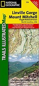
Scale 1:65,000. Size 26"x38". National Geographic edition. This Trails Illustrated topographic map is the most comprehensive and complete recreational map for the Linville Gorge and Mt. Mitchell area of Pisgah National Forest in North Carolina. All trails, campsites, and recreational features are included.
Highlights include: Pisgah National Forest; Grandfather and Appalachian Ranger Districts; Blue Ridge Parkway; Linville Gorge Wilderness area; Mount Mitchell State Park; Grandfather Mountain Biosphere Reserve; Wilson Creek Wild and Scenic River and much more. The towns of Black Mountain, Marion, Morganton, Linville and Burnsville are also included.
Write Your Own Review