
$16.95
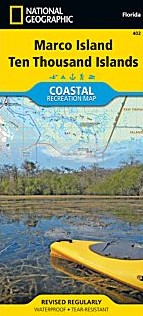
Scale 1:40,000. Size 26"x38". National Geographic edition. National Geographic's Marco Island - Ten Thousand Islands Coastal Recreation map is the ideal companion for adventures along shore and on the water.
National Geographic's new family of Coastal Recreation maps are two-sided, waterproof maps designed specifically for recreation along America's most beautiful shorelines. These hybrid maps strike the perfect balance between professional boating charts and detailed topographic maps for land. There is no other map in the market today that provides as much versatility for coastal recreation as National Geographic's Coastal Recreation series.
For paddlers, sail, and power boaters these maps are ideal for planning, cover waters up to three nautical miles off-shore, conveniently sized for use on-board a craft of any size, packed with essentially boating information, and a valuable safety companion. Beach-goers, wildlife enthusiasts, and those that enjoy exploring coastal towns will find these maps an invaluable resource for local beaches, parks, wildlife viewing areas, lighthouses, and unique places of interest.
The Marco Island/ Ten Thousand Islands Coastal Recreation map covers SW Florida from Rookery Bay to the Everglades at a scale of 1:40,000 (one inch equals 0.63 Miles). The front side of the map details the northern extent of the Everglades, Everglades City, Marjory Stoneman Douglas Wilderness, Ten Thousand Islands and the southern end of Collier Seminole State Park. The reverse, with overlapping coverage, details Marco Island, Rookery Bay, Romano Shoals and Point Romano, and Collier Seminole State Park.
The Marco Island / Ten Thousand Islands map is designed and printed in the United States on durable synthetic paper, making it waterproof, tear-resistant and capable of going anywhere you do. The map is two-sided, and is folded to a convenient size of 4.25" x 9.25"; unfolded size is 26" x 38". These maps fit easily in lifejacket, center console, or glove box.
Write Your Own Review