
$14.95
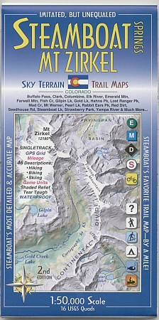
Scale 1:50,000. Size 24"x39". Sky Terrain edition. The map covers 16 USGS quads. The towns shown include Steamboat Springs, Clark, Columbine, Hahns Peak and Milner. A huge stretch of the Park Range (and the Continental Divide) is mapped, with the mighty Mount Zirkel at the highest point. Other highpoints are Lost Ranger Peak, The Dome, Mount Ethel, Big Agnes Mountain, Rabbit Ears Peak and conical Hahns Peak. Buffalo Pass, Rabbit Ears Pass, Ute Pass, and Red Dirt Pass are shown. The entire and very beautiful Elk River is revealed, as well as a long stretch of the Yampa River and smaller creeks like Soda Creek, Spring Creek, Fish Creek, Mad Creek, Walton Creek and so many more. Whitewater classes and put-ins & take-outs are shown. Steamboat Lake and Pearl Lake provide boating. And numerous alpine lakes such as Luna Lake, Three Island Lake, Gilpin Lake, Gold Creek Lake & Dinosaur Lake.
Write Your Own Review