
$18.95
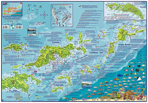
Scale 1:83,000. Size 17"x26". Franko maps edition. Laminated. Franko's map of the British Virgin Islands shows locations for scuba diving, snorkling, boating, fishing, beaches, exploring, accomodations, historical and scenic sites. One side of the map shows Tortola Island, Virgin Gorda Island, Virgin Gorda Peak National Park, Peter Island, Norman Island, Mosquito Island, Cooper Island, Salt Island, Ginger Island etc. Features locations and descriptions for dive sites and other coastal recreation sites. Reverse side of map has an overview of the area, including the island of Anegada, and an inset for Tortola town. Also includes lists of dive operators, BVI facts and geography, and island ferry information.
Franko's Maps produces recreation maps for the land and water of selected tourist destinations. The maps are all printed on plasticized paper so they are water resistant.
Write Your Own Review