
Raleigh City Street Maps | Detailed Travel Tourist
|
North Carolina City Street Maps |
North Carolina City Maps
- $18.95
Item Code : MART21360
Various scales. Size 5"x7". 104 pages. MapArt edition. contains street level information. Coverage includes Whitby, Oshawa, Ajax, Pickering, Scugog, Uxbridge, Clarington and more. -
-
- $10.95
Item Code : RAND11792
Rand McNally edition. Detailed city street map. - $10.95
Item Code : RAND11729
Rand McNally edition - $10.95
Item Code : RAND11707
Rand McNally edition -
-
- $10.95
Item Code : RAND11671
Rand McNally edition. Detailed city street map. - $10.95
Item Code : RAND11603
Rand McNally edition. Detailed city street map. - $10.95
Item Code : 11575
Chapel Hill, North Carolina, America (see also "Durham and Chapel Hill, North Carolina, America") - $10.95
Item Code : RAND11574
Rand McNally edition. Detailed city street map. - $10.95
Item Code : RAND11558
Rand McNally edition. Detailed city street map. - $249.95 + $24.80 p&h (add $40 for spring rollers)
Item Code : KAPA21125
 The Concord, NH Wall Map is laminated and includes framing rails on top and bottom for easy wall mounting.
 - $249.95 + $24.80 p&h (add $40 for spring rollers)
Item Code : UNIV11837
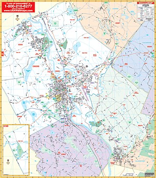
 Scale 1:2,000. Size 64" W x 46" H. Laminated. The 4th edition Winston-Salem, Forsyth County, North Carolina Wall Map from Universal Map is in complete street detail and has up-to-date cartography. Indexed in a separate book. Framing rails are included on top and bottom for easy wall mounting. A rea of coverage includes all of Forsyth County with the following boundaries: North: to the Forsyth/Stokes County line; South: to the Forsyth/Davidson County line; East: to the Forsyth/Guilford County line; West: to the Forsyth/Yadkin County line. Insets include Wake Forest University area map, Winston-Salem State University, Salem College, and a detailed Downtown Winston-Salem. The details, data, and information provided with this map include all streets, post offices, hospitals, railroads, mileage circles, points of interest, fire district lines, airports, cemeteries, shopping centers, water features, recreational parks, longitude and latitude lines, city limits, annexations, government buildings, fire and police stations, educational facilities, golf courses, country clubs, ZIP codes, ZIP code boundaries, and township names. Railed wall maps can be turned into pull down maps on spring rollers for an additional $40.
 - $249.95 + $24.80 p&h (add $40 for spring rollers)
Item Code : UNIV11825
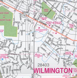
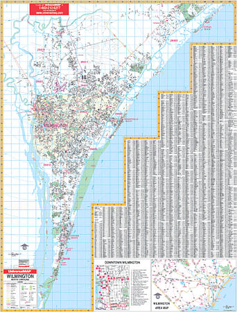 Size 46" W x 62" H. Laminated. The Wilmington, North Carolina Wall Map by Universal Map provides up-to-date cartography with new streets and changes. Offers complete street detail, lamination, street indexing. Coverage ranges north to Northeast Cape Fear River, Ole Point Country Club, and Topsail Beach; south to Fort Fisher State Recreation area; east to the Atlantic Ocean, and west to the Cape Fear River. Insets include Downtown Wilmington and Wilmington area. Details all streets, post offices, hospitals, water features, mileage circles, airports, railroads, cemeteries, shopping centers, recreation parks, ZIP codes/boundaries, government buildings, fire/police stations, educational facilities, golf courses/country clubs, and longitude/latitude lines. Framing rails are included on top and bottom for easy wall mounting. Railed wall maps can be turned into pull down maps on spring rollers for an additional $40.
 - $11.95
Item Code : UNIV11822
 Scale 1:24,000. Size 22"x26". Universal Map edition. Laminated.
 - $249.95 + $24.80 p&h (add $40 for spring rollers)
Item Code : UNIV11812
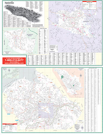 Scale 1:2,680. Size 52" W x 70" H. Laminated. Provides up-to-date cartography with new streets and changes. Printed in color with a markable/washable-laminated surface. Streets indexed on the face of the map. Includes hanging rails mounted top and bottom. Railed wall maps can be turned into pull down maps on spring rollers for an additional $40. Area of coverage: Section I: all of the county of Watauga with the following boundaries: North: to Ashe County line and Tennessee State line; South: to the Caldwell County line; East: to the Wilkes County line; West: to the Avery County line and Tennessee State line. Section II: All of the city of Boone with the following insets: Blowing Rock, Beech Mountain, Seven Devils, and Appalachian State University. Details all streets and highways, government buildings, airports, water features, fire/police stations, hospitals, shopping centers, educational facilities, railroads, recreational parks, golf/country clubs, post offices, city limits/annexations, cemeteries, ZIP codes, fire district lines, and points of interest.
 - $249.95 + $24.80 p&h (add $40 for spring rollers)
Item Code : UNIV11779
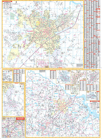 Size 54" W x 72" H. Laminated. The Salisbury and Rowan County, North Carolina Wall Map by Universal Map measures 54" x 72" and contains up-to-date cartography with new streets and changes. Detail found on this map include all streets, hospitals, cemeteries, water features, mileage circles, shopping centers, recreational parks, ZIP codes and boundaries, government buildings, fire and police stations, educational facilities, golf courses and country clubs, city limits and annexations, post offices, hospitals, railroads, and points of interest. This commercial wall map will show all of Salisbury/Rowan County in complete street detail with the boundaries as follows: North to the Davie County line; South to the Cabarrus County line; East to the Davidson county line; and West to the Iredell County line. The lower half of the map is the entire county while the upper half is the city of Salisbury. Insets include Enochville, Granite Quarry, Rockwell, China Grove, Faith, Landis, Cleveland, and the Salisbury Historical District. Framing rails are included on top and bottom for easy wall mounting. Railed wall maps can be turned into pull down maps on spring rollers for an additional $40.
 - $249.95 + $24.80 p&h (add $40 for spring rollers)
Item Code : UNIV11775
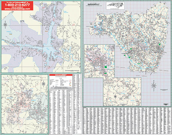 Scale 1:4,224. Size 54" W x 74" H. Laminated. Provides up-to-date cartography with new streets and changes. Printed in color with a markable/washable-laminated surface. Streets indexed on the face of the map. Includes hanging rails mounted top and bottom. Railed wall maps can be turned into pull down maps on spring rollers for an additional $40. Area of coverage: Section I: all of Rutherford County with the following boundaries: North: to the McDowell County line; South: to the Spartanburg/Cherokee County line; East: to the Cleveland County line; West: to the Henderson/Buncombe County lines. Section II: Forest City, Ruth, Rutherfordton, Spindale, Chimney Rock, and Lake Lure. Details all streets and highways, government buildings, airports, water features, fire/police stations, hospitals, shopping centers, educational facilities, railroads, recreational parks, golf/country clubs, post offices, city limits/annexations, cemeteries, zip codes, and points of interest.
|
North Carolina City Street Maps |
