
$249.95
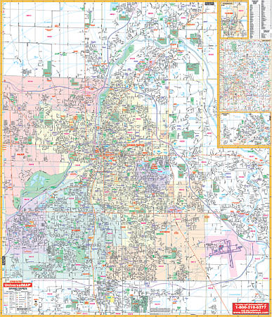
Scale 1:1,554. Size 54" W x 64" H. Laminated. The Grand Rapids, Michigan Wall Map by Universal Map shows complete street detail. Protected by a laminate surface which is both markable and washable. Indexed in a separate book. Framing rails are included on top and bottom for easy wall mounting. Boundaries as follows: North: to 8 Mile Rd ; South: to 76th. Street; East: to Cascade including Kent County International Airport; West: to the Kent County line. Includes inset map of Jenison, Rockford, and Kent County. The special features and data are as follows: all streets/highways, government buildings, airports, golf courses and country clubs, railroads, longitude/latitude lines, ZIP codes/boundaries, shopping centers, recreational parks, mileage circles, cemeteries, educational facilities, hospitals, post offices, city limits and annexations, fire/police stations, and miscellaneous points of interest. Railed wall maps can be turned into pull down maps on spring rollers for an additional $40.
Write Your Own Review