
$249.95
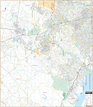
The Prince William Co., VA Wall Map by Kappa Map Group measures 59" W x 68" H and provides complete street detail with new streets and changes. The laminated surface is both markable and washable. Street indexing appears in a separate book.
The area of coverage includes all of Prince William Co., with the following boundaries: North: to the Washington Dulles International Airport; South: to just past the southern tip of Prince William County; East: to include all of the City of Vienna and the intersection of Interstate 66 & 495; West: to the Warrenton-Farquier Airport.
Other details included are as follows: airports, post offices, hospitals, railroads, points of interest, mileage circles, longitude and latitude lines, all streets and highways, cemeteries, shopping centers, water features, recreational parks, block numbers, government buildings, fire and police stations, educational facilities, golf courses and country clubs, ZIP codes and their boundaries, and city limits and annexations.
Framing rails are included on top and bottom for easy wall mounting. Railed wall maps can be turned into pull down maps on spring rollers for an additional $40.
Write Your Own Review