
$38.95
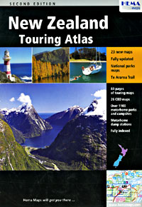
Scale 1:450,000. Size 8?"x12". 149 pages. Hema maps edition. Laminated card cover. Excellent cartography. Shows topographic features, major highways, secondary roads, urban route numbers, railways, footpaths, airports, buildings, information centers, toilets, parking areas, post offices, forests, national park boundaries, camping, golf courses, picnic areas, mountains (in heights), glaciers, and preserves. Also Includes beautiful detailed city street plans of Auckland, Whangarei, Hamilton, Tauranga, Rotorua, Taupo, Gisborne, Napier, Hastings, New Plymouth, Wanganui, Palmerston North, Wellington, Blenheim, Nelson, Christchurch, Timaru, Oamaru, Dunedin, Queenstown, and Invercargill. BIG>> SAMPLE MAP << Small sample map
Write Your Own Review