
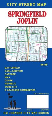
Springfield and Joplin City Street Map, Missouri, America.
$14.95
In stock
Scale 1:32,000. Size 27"x39". G.M. Johnson edition. This Map Coverage Area are Battlefield, Fremont Hills, Nixa, Ozark, Republic, Springfield, Airport Drive, Avilla, Brooklyn Heights, Carl Junction, Carterville, Carthage, Cliff Village, Dennis Acres, Duenweg, Duquesne, Fidelity, Joplin, Leawood, Oronogo, Redings Mill, Saginaw, Shoal Creek Drive, Shoal Creek Estates, Webb City, Christian County, Greene County, Jasper County, Newton County Partial Coverage.
Scale 1:32,000. Size 27"x39". G.M. Johnson edition. This Map Coverage Area are Battlefield, Fremont Hills, Nixa, Ozark, Republic, Springfield, Airport Drive, Avilla, Brooklyn Heights, Carl Junction, Carterville, Carthage, Cliff Village, Dennis Acres, Duenweg, Duquesne, Fidelity, Joplin, Leawood, Oronogo, Redings Mill, Saginaw, Shoal Creek Drive, Shoal Creek Estates, Webb City, Christian County, Greene County, Jasper County, Newton County Partial Coverage.
| Item Price | $14.95 |
|---|
Write Your Own Review